
Page 570 - Ebook HTKH 2024
P. 570
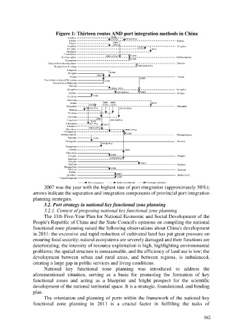
Figure 1: Thirteen routes AND port integration methods in China


                        2007 was the year with the highest rate of port integration (approximately 50%);
                  arrows indicate the separation and integration components of provincial port integration
                  planning strategies.
                        3.2. Port strategy in national key functional zone planning
                        3.2.1. Context of proposing national key functional zone planning
                        The 11th Five-Year Plan for National Economic and Social Development of the
                  People's Republic of China and the State Council's opinions on compiling the national
                  functional zone planning raised the following observations about China's development
                  in 2011: the excessive and rapid reduction of cultivated land has put great pressure on
                  ensuring food security; natural ecosystems are severely damaged and their functions are
                  deteriorating; the intensity of resource exploitation is high, highlighting environmental
                  problems; the spatial structure is unreasonable, and the efficiency of land use is low; the
                  development  between  urban  and  rural  areas,  and  between  regions,  is  unbalanced,
                  creating a large gap in public services and living conditions.
                        National  key  functional  zone  planning  was  introduced  to  address  the
                  aforementioned  situation,  serving  as  a  basis  for  promoting  the  formation  of  key
                  functional  zones  and  acting  as  a  blueprint  and  bright  prospect  for  the  scientific
                  development of the national territorial space. It is a strategic, foundational, and binding
                  plan.
                        The orientation and planning of ports within the framework of the national key
                  functional  zone  planning  in  2011  is  a  crucial  factor  in  fulfilling  the  tasks  of


                                                                                                          562